News

The Flint Water Crisis – What is happening, and what are the consequences? - PAESTA Podcast Series: Episode 7

You Asked, We Answered!

Transcript for the podcast

Hello my name is James Clark and I am an undergraduate student at Penn State Brandywine. In this podcast, I will be answering the following questions that pertain to the Flint water crisis. Who is to blame? What caused the Flint water crisis? Was the Flint water crisis preventable? What are the lasting consequences? What are the political ramifications? Along with these questions, I will also answer some common questions that people are asking about the Flint water crisis.

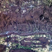
My 8th grade Earth Science students requested this image from the International Space Station's EarthKAM camera during the April, 2016 EarthKAM Mission.  During the time of the photograph, a cool, clear high pressure system was situated over the northeastern United States, making for excellent viewing opportunities.  If you teach science, the EarthKAM program is a free NASA resource you really should look into.  More info can be found here: https://www.earthkam.org.  The actual image is hosted on the EarthKAM servers, which are managed by the US Space and Rocket Center in Huntsville, Alabama.  If you click the picture link, there are opportunities to download this an other images at various resolutions:   http://images.earthkam.org/main.php?g2_itemId=588076  By clicking the "next image" and "previous image" buttons, you can sometimes view excellent overlapping images taken by the ISS as it orbited Earth at an astounding speed of 17,000 mph, close to 5 miles a second!  There are at least two April, 2016 EarthKAM images which caught the PSU campus and surrounding countryside.  Plenty of other excellent pictures of Earth from this and other EarthKAM missions going back nearly a decade.  Check them out in the EarthKAM image galleries.

One of the more interesting things that you can do with these EarthKAM images is to compare them with the images hosted by Google Earth to see change over time.  To make that easier, here is a Google Maps link to the EarthKAM image discussed in this post  (works best with Chrome browser).

PSU's Happy Valley From Space (ISS) EarthKAM

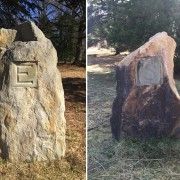
Look - we found "E" (for Earth) and "S" (for Science) on rocks! And we already knew that Earth Science rocks! Actually, these compass directions are part of the markers in the Stopford Family Meadow Maze at Tyler Arboretum (link is external) in Media, PA.

Earth Science Rocks

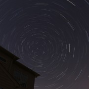
I've always been amazed by the beautiful star trail photos I see professional photographers make.  Apprarently, it's really not that difficult to take these, and there are tons of websites that will walk you through the process.  This one is a "stacked" image that combines 30, 2 min exposures at f/4 and iso400.  Camera was a Canon 70D with a 18-55mm lens set to 24mm.  Total photo time - 60 minutes (1hr).  Based on this, I would expect that each of the star trails, which are caused by Earth's rotation, would trace out an arc of 1/24th of a full 360 degree circle, or about 15 degrees or arc, with Polaris at the center.  Notice the pulsed light from an airplane that flew over at some point during the hour.

Aside from "stacking" the images with free software available online, the picture was not adjusted or enhanced in any other major way.  More to come once I figure out how to work the camera and intervalometer better!

Picture taken from 10:55pm-11:55pm looking due north at approximate altitude of 40 degrees, from my back yard in Pipersville, PA.

Polaris_60_min_Star_Trails

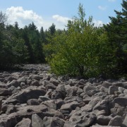
Succession is causing Hickory Run State Park's Boulder Field to shrink, albeit quite slowly, as trees take root amongst the rocks.  The field, which is the size of ten football fields, is believed to have been formed during the last ice age.

Trees Encroaching on Boulder Field

PAESTA Podcast Series: Episode 4 - What is a Watershed?

You Asked, We Answered!

Transcript for the podcast

We all live in a watershed – think of it as your ecological address, and no matter where you are on land, any water that falls in that same location has a drainage destination determined by elevation and landforms. A watershed is an area of land where the surface water (including lakes, streams, reservoirs, and wetlands) and the underlying groundwater flows from a higher to lower elevation. Streams and rainfall within a watershed will typically drain to a common outlet, such as the outflow of a reservoir, mouth of a bay, or any point along a stream channel. The word watershed is sometimes used interchangeably with drainage basin or catchment.

PAESTA Podcast Series: Episode 3 - How do Scientists Measure Rainfall?

You Asked, We Answered!

Transcript for the podcast

Many schools will have a rain gauge installed, where students can measure and record the amount of rain that falls each day. But scientists do not measure precipitation on the ground – they measure precipitation from space, using a combination of active and passive remote-sensing techniques, improving the spatial and temporal coverage of precipitation observations on a global scale.  You see, reliable ground-based precipitation measurements are difficult to obtain because most of the world is covered by water, and many countries do not have precise rain measuring equipment (such as rain gauges and radar). Precipitation is also difficult to measure because precipitation systems can be somewhat random and can evolve very rapidly. During a storm, precipitation amounts can vary greatly over a very small area and over a short time span.

PAESTA Podcast Series: Episode 2 - What is the Difference Between Paleontology, Archaeology, and Anthropology?

You Asked, We Answered!

Transcript for the podcast

These career fields are front and center in pop culture, thanks to Hollywood blockbuster films, such as the Jurassic Park and Indiana Jones series. Unfortunately, popular culture can sometimes blur the boundaries and misrepresent these disciplines. This podcast explores the differences between the three fields of paleontology, anthropology, and archaeology.

Pages